Educational maps help students explore geography, learn country locations, and visualize spatial relationships. This article showcases five reliable, classroom-ready maps and a printable workbook option, designed for durability, readability, and classroom practicality. Each pick offers durable lamination, vivid details, and age-appropriate layouts to support interactive learning in homes, classrooms, and study spaces.
| Product | |
|---|---|
| Laminated World Map & US Map Set | 18″ x 29″ |
| US & World Desk Map | 13″ x 18″ |
| Maps International Giant World Map | 46″ x 80″ |
| Blank USA Map Outline Poster | 18″ x 29″ |
| National Geographic United States Wall Map | 43.5″ x 30.5″ |
Laminated World Map & US Map Set

The Palace Learning map set includes both an updated world map and a United States map on 18″ by 29″ posters. These laminated posters provide durable, long-lasting use in classrooms and study spaces. The dual posters help students compare continental layouts with U.S. geography, time zones, and capital placements. The 3-mil lamination adds protection against daily wear, making these posters suitable for wall displays, learning centers, and group activities.
US and World Desk Map
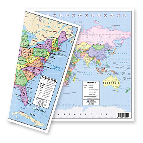
This two-sided desk map offers a compact, portable option for students or teachers who need quick reference tools at a desk. One side presents a political US map in pastel colors, while the flip side shows a world map. The US map highlights all fifty states, Alaska and Hawaii inserts, major cities, time zones, and state capitals marked with red stars. The world side provides a clear political overview with up-to-date details, while Europe includes an enlarged inset for easier study of this densely mapped region.
Maps International Giant World Map

This mega-map is designed as a bold classroom centerpiece. Measuring 46 by 80 inches, it’s a 1:20 million scale world map with hill and sea shading to provide depth. The map is laminated for durability and can be written on with whiteboard markers and wiped clean, making it ideal for geography lessons, group activities, and visual demonstrations. The large format supports multiple learners in a single view, fostering discussion about continents, countries, and geographic relationships.
Blank USA Map Outline Poster

The blank 18″ x 29″ laminated USA outline poster provides a versatile canvas for hands-on learning. The poster’s material supports dry-erase or wet-erase markers for interactive labeling, coloring, and map-based activities. The durable lamination helps withstand student use over time, making it suitable for geography centers, small-group work, and classroom wall displays.
National Geographic United States Wall Map

National Geographic’s United States Wall Map delivers high-quality, up-to-date geographic detail in a classroom-friendly format. This wall map emphasizes current political boundaries, major cities, and geographic features with the trusted National Geographic standard. While slightly larger, this map serves as a central teaching tool for lessons on state locations, capitals, and regional geography, complementing smaller desk maps and posters in a balanced classroom setup.
USA Map For Kids — Laminated

This 18″ x 24″ laminated map offers durability and bold visuals for classroom walls or homeschooling spaces. The lamination provides durability for long-term display, while the 18 by 24 size ensures a clear, readable layout from a distance. The poster is designed to make a visual impact and foster recognition of U.S. geography in younger learners and busy classrooms alike.
United States Map – Classroom Pack

This bulk USA poster set presents a detailed map with capital cities and state names in a readable font. Although listed as a classroom- or office-friendly option, it remains suitable for homeschooling or group study areas. The 12 x 18 inch size on glossy stock offers clear color separation and easy legibility, making it a practical addition for displays, centers, and study corners.
School Zone Travel The Great States Workbook

This 64-page workbook offers geography-focused activities to reinforce map-reading and U.S. state knowledge for 3rd grade and above. It includes a variety of exercises that support independent practice, guided lessons, and workbook-based assessments. The workbook’s age-appropriate activities provide structured reinforcement aligned with classroom geography objectives.
Buying Guide: Key Purchase Considerations
- Durability and lamination: Choose laminated maps for classrooms to withstand frequent handling and erasing. Thicker lamination reduces wear in busy spaces.
- Size and visibility: Larger maps are ideal for whole-class demonstrations, while smaller desk maps support individual learning centers and task cards.
- Detail and readability: Prioritize maps with clear country, state, and city labels, readable fonts, and color-coding to support quick recognition.
- Dual-sided and inset maps: Desk or desk-ready options with dual sides or regional insets help broaden geographic coverage without switching materials.
- Update frequency: For national and global maps, consider recent editions or updated 2025 materials to reflect current borders and political changes.
- Type of use: Wall maps support whole-class instruction; desk maps and workbooks support hands-on activities and individual practice.
- Materials and origin: Domestic production can support local manufacturing while ensuring quality control; check lamination of 3 mil or thicker for durability.
- Write-on capability: Maps that are write-on/wipe-off with whiteboard markers enable interactive activities and quick corrections.
- Age appropriateness: Align map complexity with students’ grade level, from elementary to middle school to ensure comprehension.
- Inclusivity of features: Look for maps that show capitals, time zones, major cities, and physical features to enrich lessons beyond borders and borders.