Finding kid-friendly world maps that engage young learners can boost geography curiosity while supporting classroom decor or homeschool routines. This article highlights five highly-rated options that combine bright visuals, durable materials, and age-appropriate labeling. Each pick emphasizes continents, countries, capitals, and flags in a way that fosters memory, spatial awareness, and independent exploration for children aged 4 through 12.
Summary of selected products
| Product | Type | Best For |
|---|---|---|
| World Map Poster & US Map Set (Momo & Nashi) | Two posters | Preschool to early elementary |
| Mapology World Map Puzzle (Imagimake) | Jigsaw puzzle | Hands-on geography |
| Mapology USA & World Map Puzzle (Imagimake) | Jigsaw puzzle | Comprehensive geography |
| My World i-Poster (BEST LEARNING) | Interactive poster | Tech-enhanced learning |
| Rand McNally Illustrated World Wall Map | Poster map | Durable wall reference |
World Map Poster & US Map for Kids – 2pc Set

This two-poster set includes a World Map and a United States Map designed for early learners. Suitable for toddlers and preschoolers, the posters emphasize continents, countries, and U.S. states with engaging, artist-drawn icons. They aim to support visual learning, memory retention, and exploration in classrooms, playrooms, or homeschool spaces. The color palette is bright but carefully balanced to avoid overstimulation, with clear labels that help young readers locate regions and landmarks.
Key features include durability for classroom use and up-to-date geographic details. The posters are crafted to capture children’s attention without overwhelming them, making them ideal for daily geography prompts, storytelling, or interactive lessons. Use this 2-poster set to layout a geography corner or wall display that grows with the child from toddler years through the early elementary stage.
Imagimake Mapology World Map Puzzle

This world map puzzle combines country flags and capitals into a hands-on learning experience. The set includes frames, 75 country-shaped pieces, 65 flags with learning stickers, and a Europe map for broader geographic context. It supports spatial awareness, memory, and problem-solving as kids piece together the world while referencing capital cities and national symbols. The design encourages independent play while also inviting guided exploration by a parent or teacher.
Designed for ages 5–8 and up, the puzzle emphasizes clear geometry and proportional country shapes, helping children visualize borders and relative sizes. The included flags and fact stickers provide quick, engaging reinforcement of geography knowledge. This is an excellent option for classroom centers, homeschooling, or family game nights that blend education with interactive fun.
Imagimake Mapology USA & World Map Puzzle

This jumbo puzzle package places USA, World, and Europe maps in one box, combining state and country shapes with flags and capitals. It’s designed to foster geography knowledge, spatial reasoning, and problem-solving skills. The pieces fit into distinct puzzle frames to guide learners through assembly, reinforcing continent-to-country relationships and national symbols. Suitable for kids in late elementary grades and as a challenge activity for capable younger learners, it offers a scalable learning curve as geography interests grow.
With themes that cover U.S. geography, world regions, and European layout, the puzzle encourages cross-regional comparisons. Capitals and flag stickers add layers of information that can be incorporated into brief lessons or discussion prompts. This set is a solid choice for families and classrooms seeking a comprehensive, tactile geography experience.
BEST LEARNING i-Poster My World
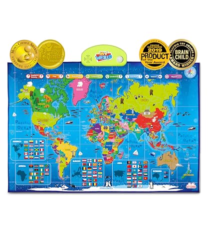
The My World interactive poster invites children to explore countries, oceans, continents, and landmarks through touch-based prompts and facts. The poster emphasizes a world-scale view with easy-to-access information, making it suitable for older preschoolers and elementary students. The interactive approach is complemented by visuals that support memory and curiosity, and the product is recognized for encouraging STEM-oriented geography exploration in homes and classrooms alike.
Content includes a variety of learning prompts that tap into listening, speaking, and visualization skills. The poster’s design is aimed at reducing barriers to geography comprehension while providing a reliable reference point for ongoing geography activities. This option blends digital-like engagement with a tangible, wall-mounted resource, ideal for learning corners or nature/science centers.
Rand McNally Kids’ Illustrated World Wall Map

This paper-rolled wall map from Rand McNally presents a color-coded world with native flora, fauna, landmarks, and cultural icons, enriching the visual appeal and learning potential. Capitals, major cities, and bodies of water are labeled to enhance geographic reference points for young readers. The map’s durability and traditional poster format make it suitable for frequent wall display in classrooms, playrooms, and study spaces. It serves as a straightforward reference that supports ongoing geography lessons and independent exploration.
The illustrated approach helps children recognize regional similarities and differences, while the labeled features provide anchors for early country recognition and cultural awareness. The map is lightweight enough for easy mounting and relocation within a learning environment, making it a reliable long-term geography reference.
Buying Guide: Key considerations for choosing kid-friendly world maps
- Age appropriateness: Match complexity to your child’s age and current geography knowledge. Simpler posters work well for toddlers, while puzzle sets and interactive maps suit older kids.
- Durability and material: For classrooms or high-traffic areas, prioritize laminated posters or sturdy puzzle pieces and frames that resist tearing and wear.
- Label clarity: Look for legible fonts, color-coded continents, and clear country names to reinforce learning without confusion.
- Interactive vs. passive learning: Interactive maps, audio features, or sticker sets encourage active participation, while traditional maps provide reliable reference material.
- Comprehensive scope: A mix of world, continents, and country-level representations helps learners connect global geography with local regions.
- Updates and accuracy: Prefer maps that reflect current geopolitical boundaries and recognized names to minimize outdated information.
- Space and display needs: Consider wall size, room layout, and whether you want a freestanding puzzle or a wall-mounted poster collection.
- Expansion potential: Some sets blend with other educational tools (flags, capitals, landmarks) for a richer learning experience over time.
- Budget and storage: Puzzles may include multiple pieces and frames, so plan for organized storage and safe handling for younger children.
These options collectively cover a spectrum of formats—from two-poster sets and laminated posters to interactive, sticker-enhanced and puzzle-based maps. Your choice will depend on teaching style, space constraints, and the age range you’re serving. Selecting a mix of visual references and hands-on activities tends to foster deeper geography understanding and a sustained interest in the world.