Explore a curated selection of world map posters that blend education, travel planning, and room décor. Whether you’re teaching geography, plotting adventures, or sprucing up a study space, these posters offer detail, durability, and easy framing. The following five options cover laminated, scratch-off, and traditional printed formats to fit different preferences and spaces.
| Product | Brand | Format | Highlights |
|---|---|---|---|
| Laminated World Map & US Map Poster Set | Palace Learning | Laminated 18″ x 29″ | Durable lamination; USA and world maps; Made in USA |
| Scratch The World Travel Map – Frameable | Maps International | Scratch-off 23″ x 33″ | Country/state borders; detailed cartography; updated 2025 |
| World Premier Wall Map Poster Mural | Swiftmaps | 24″ x 36″ | 3D shaded relief; portable folded edition |
| Giant World Map – Mega-Map | Maps International | 46″ x 80″ | Large format; laminated; 1:20,000,000 scale |
| Scratch Off World Map Poster with USA Map | InnovativeMap | Scratch-off 17″ x 24″ world; USA included | Accessories set included; detailed labeling |
Laminated World Map & US Map Poster Set

The Palace Learning set combines a world map with a dedicated United States map, both printed on sturdy 18″ by 29″ posters and finished with 3 mil lamination for durability. The laminated surface resists moisture and wear, making it suitable for classrooms, kitchens, or home offices. The glossy coating helps sharpen colors and improve legibility, aiding geography lessons and travel planning alike. The set is manufactured in the USA, which may appeal to buyers seeking domestic production and supporting local jobs.
Scratch The World Travel Map – Frameable Scratch Off World Map
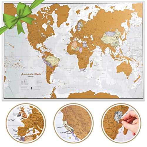
This Maps International frameable scratch-off map offers an extra-large 23″ by 33″ format with country and state borders clearly delineated. The map is designed for travelers who want to reveal destinations as they visit. The 2025 update ensures current country boundaries and features, with a gold-coated scratch layer that uncovers a colorful political map beneath. The product’s history of map-making runs over five decades, with production teams in Minnesota and the UK, emphasizing quality cartography and durable materials.
Swiftmaps World Premier Wall Map Poster Mural

The Swiftmaps World Premier poster emphasizes portability and detail, shipped as a folded edition for easy handling. Printed on 24-lb paper, it includes 3D shaded relief for a tactile sense of terrain, helping students and planners grasp elevation changes and geographic features. The folded format is practical for transport or temporary displays, while the relief shading adds a dimensional look to the classic wall map.
Maps International Giant World Map – Mega-Map

The Mega-Map from Maps International offers a colossal 46″ by 80″ laminated world map with a 1:20,000,000 scale. Its large format makes it a centerpiece for classrooms, lobbies, or conference rooms, presenting comprehensive political detail with hill shading and clear national boundaries. The heat-sealed, write-on surface enables quick labeling and notes with whiteboard markers and can be wiped clean for reuse, supporting ongoing teaching or planning needs.
InnovativeMap Scratch Off World Map Poster

InnovativeMap combines a 17″ by 24″ scratch-off world map with a detailed US map and a complete accessories set. The kit includes a scratch tool, stickers, and a magnifier, making it a ready-to-use educational and decorative piece. Labels highlight countries, states, and capitals, adding value for classrooms or homes where geography is part of daily learning. The design emphasizes clarity and ease of marking travels, complemented by a visually engaging scratch-off experience.
Buying Guide: Key Purchase Considerations
When selecting a world map poster, consider material, format, and intended use. Laminated maps offer durability and wipe-clean surfaces, ideal for high-traffic spaces and classrooms, while scratch-off maps provide a interactive visual record of travel experiences. Size matters: larger maps give more detail but require bigger display areas and framing. Look for clarity of political boundaries, color contrast, and legibility of country and city labels. If you plan to annotate maps, a write-on/wipe-off surface or included accessories can be a major convenience. Framing compatibility, mounting options, and wall color should also influence your choice. For educational settings, durability and up-to-date cartography are important; for home decor or travel planning, visual appeal and the ability to quickly highlight places matter more. Consider whether you need country-state detail, or more cosmopolitan features like hill shading, bathymetry, and 3D relief. Finally, assess any included extras—laminating film, pens, stickers, or flag sets—that enhance usability and engagement.
Product variety shown here spans laminated and scratch-off formats from multiple brands, offering choices based on size, interactivity, and display environment. Compare the level of detail, update frequency, and where the maps are produced to match your priorities—education, travel inspiration, or room design.