Discover top-rated map-based learning toys and wall posters designed to spark kids’ curiosity about countries, capitals, oceans, and cultures. This guide highlights interactive maps, durable wall posters, and fun geography games that fit homes, classrooms, and homeschool setups. Each pick combines engaging visuals with educational content, helping children build foundational geography knowledge through play.
| Product | Brand | Format | Key Benefit |
|---|---|---|---|
| BEST LEARNING i-Poster My World | BEST LEARNING | Interactive map | Over 500 voice-guided questions for immersive learning |
| World Map Poster & US Map 2pc Set | Momo & Nashi | 2 posters | Bright, kid-friendly visuals for continents and the U.S. |
| BEST LEARNING i-Poster My USA | BEST LEARNING | Interactive map | 500+ spoken facts about states and capitals |
| 2 Pack World & USA Map For Kids | Palace Learning | 2 posters | Durable laminated posters for classrooms and homes |
| Rand McNally Kids’ Illustrated World Map | Rand McNally | Wall map | Colorful illustrations with labeled capitals and major features |
BEST LEARNING i-Poster My World
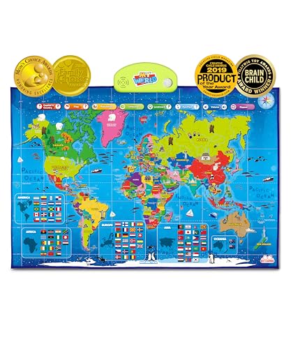
Interactive world map designed for ages 5-12, allowing children to tap a country and hear its name, capital, and fun facts. With more than 500 voice-guided questions, the map turns geography into an engaging storytelling experience. The educational toy has earned Family Choice and Brain Child awards, signaling credible learning value. By exploring oceans, continents, landmarks, and flags, kids improve earth science comprehension and cross-cultural awareness through interactive play. The device-friendly format supports independent play or guided lessons, making it suitable for classrooms and at-home learning environments.
World Map Poster & United States Map 2pc Set

This 2-piece educational poster set includes a world map and a United States map, designed for kids ages 3-5 and up. Bright, inviting illustrations help sustain visual attention while teaching continents, countries, and U.S. states. The posters are ideal for preschool classrooms, playrooms, or homeschool spaces, offering durable visuals that withstand frequent handling. Clear labeling supports early geography recognition and memory development, helping young learners connect locations with real-world contexts in a clutter-free display.
BEST LEARNING i-Poster My USA

Interactive United States map for kids ages 5-12, highlighting states, capitals, and more than 500 spoken facts. This engaging tool supports geography memory skills as children tap any state to learn its name and capital. Recognized with multiple awards for educational value, the map also offers flexible learning setups—hang on a wall or use as a floor mat for quizzing sessions at home or in classrooms. It provides a hands-on approach to U.S. geography, complementing traditional map studies with auditory reinforcement.
2 Pack World & USA Map For Kids

Two laminated posters—world map and USA map—designed for durability and repeated handling in busy learning spaces. Each poster features clear labeling and kid-friendly artwork to promote recognition of continents, countries, and U.S. states. The laminated 18″ x 29″ format supports classroom walls or home study areas, providing long-lasting visuals that stand up to daily use. This set is ideal for early geography exposure, memory-building activities, and classroom decor that reinforces spatial awareness.
Rand McNally Kids’ Illustrated World Map

This illustrated world map by Rand McNally adds a playful touch to geography education. Color-coded continents feature native flora, fauna, landmarks, and cultural icons to capture curiosity. Capitals, major cities, and bodies of water are labeled to provide essential reference points as kids explore the world. Printed on durable heavy paper, the map is suitable for classrooms and study rooms, offering a reliable, long-lasting educational tool that pairs well with supplementary resources for geography lessons.
Buying Guide: Map-Based Learning Tools For Kids
- Age appropriateness: Look for interactive features for younger children (ages 5-8) and more detailed content for older kids (9-12).
- Format and durability: Laminated posters withstand frequent handling; interactive maps encourage long-term engagement. Consider where the map will be used (wall, floor, or桌).
- Learning style compatibility: Choose tools that combine visuals with auditory or tactile elements to support diverse learners. Interactive quizzes, voice guidance, and colorful illustrations aid memory.
- Content breadth: A comprehensive tool should cover continents, oceans, landmarks, capitals, and flags. For U.S.-focused learning, ensure state names and capitals are included.
- Award signals and credibility: Awards from education-focused organizations can indicate trusted quality and classroom suitability.
- Multiplayer and solo use: Some products support family quizzes and classroom activities; others are designed for individual exploration. Consider your preferred usage scenario.
- Storage and display: Posters that roll or lie flat store easily when not in use. Interactive maps should be easy to mount and use in varied spaces.
- Budget and value: A bundle with both world and USA maps often offers better value for households or classrooms expanding geography coverage.