Explore a curated selection of educational maps and map-themed activities designed for kids. From colorful wall posters to interactive talking maps and hands-on puzzles, these resources help children learn about countries, states, capitals, and continents in a fun, engaging way. The following picks emphasize visual learning, durable design, and age-appropriate complexity for preschool to preteen learners.
| Product | Type | Age Range | Highlights |
|---|---|---|---|
| World Map Poster & Map of the United States for Kids – 2pc Set | 2 Poster Set | Toddlers to 5th grade | Bright, kid-friendly illustrations; up-to-date labeling; suitable for classrooms and homes |
| 2 Pack – World & USA Map for Kids [Illustrated] – 2 Poster Set | Posters (Lamination) | Preschool to early elementary | Durable laminated posters; compact 18″ x 29″ size |
| BEST LEARNING i-Poster My USA | Interactive Map Poster | 5-12 years | Voice-enabled with state names, capitals, and fun facts |
| Imagimake Mapology USA & World Map Puzzle | Puzzle Kit | 8-12 years | Country shapes, flags, and capitals; multi-map focus |
| BEST LEARNING i-Poster My World | Interactive World Map Poster | 5-12 years | Voice-guided facts; broad geographic learning |
style=”display:none;”>Product Summary
Note: The summary above highlights a mix of posters and puzzles designed to support geography learning through visuals, hands-on activities, and interactive play. Each option emphasizes age-appropriate content, durability, and classroom-friendly design to help kids develop map literacy and global awareness.
World Map Poster & USA Map Set — Momo & Nashi

The 2-piece poster set combines a World Map and a United States Map in bright, engaging artwork designed for early learners. The illustrations aim to spark curiosity about continents, countries, and U.S. states while maintaining a clean, non-distracting layout that supports visual memory and recall. The design targets toddlers through early elementary students, with easy-to-read labels and durable poster construction suitable for classroom walls or playroom decor.
Key features include up-to-date geographic details, artist-style icons, and high-contrast colors meant to draw attention without overwhelming young viewers. The two-poster format makes it simple to center geography lessons around both global and national perspectives, ideal for homeschool environments or preschool classrooms seeking printed reference tools.
2 Pack World & USA Map for Kids — Laminated Posters

This 2-poster set features a World Map and a United States Map in a ready-to-use laminated format. Each poster measures 18″ x 29″ and is designed for durability in busy classrooms or home learning spaces. The laminated surface protects against spills and handling wear, making them suitable for repeated daily reference as children begin to explore geography beyond their immediate surroundings.
Designed for young learners, these maps emphasize recognizable continents, major countries, and state-level cues with straightforward labeling. The durable lamination supports classroom displays and quick wipe-down cleaning after activities, helping long-term use in early literacy and geography curricula.
BEST LEARNING i-Poster My USA

The interactive USA map invites kids to tap states and hear their names, capitals, and over 500 facts. This engaging learning toy blends wall-display potential with interactive floor play, making it suitable for both classroom wall setups and active learning sessions at home. The product is designed to help build memory, geography knowledge, and recall through auditory reinforcement, which can benefit different learning styles.
As an award-winning educational tool, it combines durability with interactive features that support independent study and collaborative quizzes. The layout supports visual and aural learning pathways, helping students connect state locations with capital names and regional trivia without relying solely on text.
Imagimake Mapology USA & World Map Puzzle

Imagimake’s Mapology kit combines USA, World, and Europe maps into a single puzzle set, featuring country shapes, flags, and capitals. This multi-map approach encourages spatial reasoning and geography literacy through hands-on puzzle assembly. The pieces are designed to fit actual geographic shapes, reinforcing recognition of borders and regional relationships as children place each state or country piece into its correct position.
With stickers for flags and facts, this kit adds contextual learning beyond mere placement. It supports kinesthetic and visual learners by turning geography into a puzzle experience, making it a strong option for homeschoolers and classroom groups seeking interactive, tactile exploration of global geography.
BEST LEARNING i-Poster My World
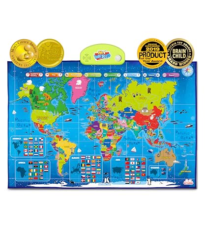
The World version of the interactive i-Poster expands geography learning to global contexts. Users tap on various countries to hear names, capitals, and fun facts, with a library of more than 500 voice-guided prompts. This format supports curiosity about continents, oceans, landmarks, and flags while nurturing memory through auditory cues and repetition.
As with the USA version, this world map poster is suitable for wall display or floor activities, providing flexible learning setups in homes and classrooms. It helps learners connect spatial locations with cultural and political information, broadening geographic awareness and encouraging inquiry about our planet.
Buying Guide: Key Purchase Considerations and Comparisons
- Learning style fit: Choose between static posters for visual reference and interactive maps for auditory and kinesthetic learning. Some options combine both formats for well-rounded geography education.
- Age appropriateness: Posters and simple puzzles work well for preschoolers and early elementary students, while more complex puzzles or interactive maps suit older children and transitional learners.
- Durability and placement: Laminated or matte posters endure high-traffic areas, while floor puzzles require sturdy, kid-safe materials. Consider wall vs. floor learning setups when selecting products.
- Content scope: Decide whether you want a focus on the USA only, world geography, or a mix of both. Some kits include capitals, flags, and fun facts to deepen context.
- Interactivity level: Interactive maps with audio can boost engagement and memory retention, but backup poster references are useful for quick checks in busy classrooms or playrooms.
- Size and display flexibility: Larger posters are more impactful on classroom walls, but smaller laminated sets can be easier to store and transport for field trips or homeschooling sessions.
- Teacher and parent usability: Look for products designed for guided lessons or independent exploration. Clear labeling and age-appropriate challenges help instructors structure geography activities efficiently.
- Accessibility considerations: Audio-enabled maps should be easy to operate for children with various learning needs. Durable builds and tactile pieces support inclusive learning approaches.